User guide
Version 3 of the application continues the process started in version 2 and brings improvements, but also major conceptual changes.
First of all, version 3 introduces the possibility to use the application on 3 user levels, each with a set of benefits:
- Visitor (without an account); works online and offers a minimum of information;
- Authorized (Muntii Nostri account) - account, either previously created on Muntii Nostri website or a newly created one;
- Explorer Account, to benefit from all the options; subscriptions available for 3 months or 6 months.
1. Visitor
Benefits:
- The application can be used as a visitor, without creating a new account, with a minimum of information available;
- The application works online;
- It opens with a list of trails (as in version 2 of the application), ordered by distance from the user;

- Search: you can search for trails by name, number or item in the stages of the trail;
E.g.: 'omu', 'scarisoara', etc.

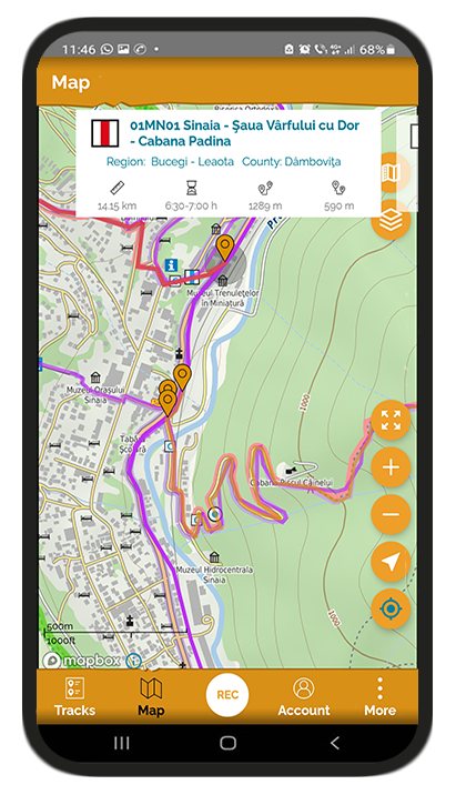
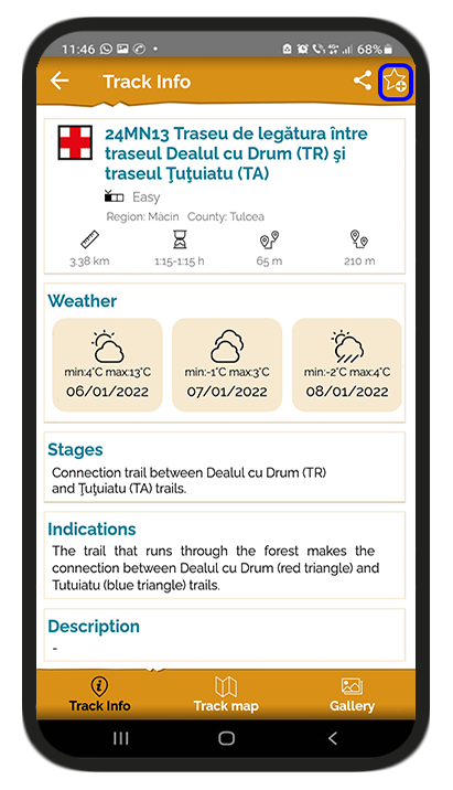
- The Trail info section presents the trail parameters, geographic location, weather, stages;
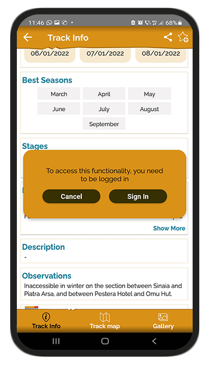
- Trail description and information is limited and requires creating an account;
- Trail map and available options:
- legend button
- map layers
- return to the original extent
- zoom in/out button
- location/direction button

- Elevation profile - is activated by pressing the arrow with the tip up, above the trail Map section;

- Measurement: by moving the segment ends to the left or to the right, a measurement of the desired trail segment is obtained;

- Approximate elevation is obtained by placing the finger on the profile and sliding over it. The values are approximate and different from the official measurements, due to the elevation model that has a lower resolution;
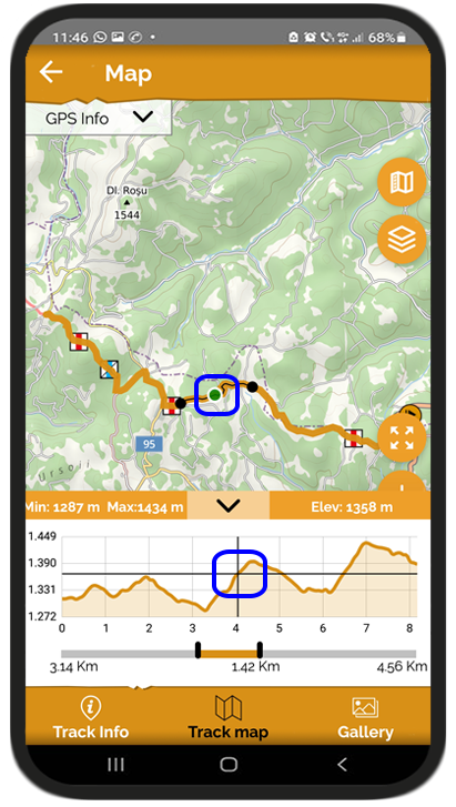
- The GPS info panel offers details about the current location. Latitude and longitude are shown in decimal degrees, while the altitude and the accuracy are shown in meters. The accuracy depends on the smartphone specifications and the terrain characteristics (in canyons, gorges, forests the accuracy will be lower).

- The option to share a trail on social networks from the screen with trail details;

- The option to send feedback from the More menu;
- Change the language on the application, access Facebook or Instagram accounts from the More section;
- Access the online store within each trail.
- This type of account also shows ads.
Options such as:
- Access personal account
- Sort or filter trails;
- Set trail as favorite;
- Post comments;
- Access detailed directions;
- Access to satellite images
are only available with your Muntii Nostri account.
2. Authorized (Muntii Nostri Account)
The created account is accessed based on a username or e-mail and a password.
In case you forgot your password, it can be reset by sending an email containing a link to reset your password. In case it does not reach the inbox, please also check the spam folder.
What can be done:
- The application works online;
- Create a new account: use the new account option.
- Muntii Nostri account makes the connection between the website and the application. In this way, the routes planned on the site or the favorite routes are visible in the application, in My Account section, to be used on the mountain.
- The application opens with the grouping of trails by types of activities (hiking, cycling) and then by mountain groups or regions. In each region the trail list opens with the trails ordered according to the distance from the user.

- Sort: Trails can be sorted alphabetically or by distance.

- Filter: Next to the sort button, there is the filter button; the trails can be filtered by difficulty, duration, length, ascent

- General trail map - the trails can also be accessed from the map. The map opens with a detailed view of Romania, in order to visually cover the entire area. By zooming in, you can further see the trail route.
- Trail selection: Trails can be selected either by clicking on the starting point or by clicking on the route. o If there are several trails that start from approximately the same place and can no longer be differentiated by a more detailed zoom, then you can click on that area and a carousel with the trails available in that location opens up. Scrolling to the left, the trails available for that area will appear, and the trail in the central area will also be the one selected on the map.
- Access to additional options on the map:
o Satellite images (satellite and satellite streets, provided by Mapbox)
- My tracks button, that activates or deactivates my track on the maps
- Muntii Nostri trails button that activates or deactivates the trails on the map

- Trail information - access to directions and description is unlimited.
- You can set a trail as favorite and it will be found immediately in the favorite trails section on your account.
- Access to My Account section that allows viewing custom trails grouped by sections:
- My trails:
- If the planning starts from home, the trails created and planned on the website can be accessed in the field.
- Here you can also find the trails registered on route, in case you have activated an Explorer account and after registration they have been uploaded on the server.
Planning routes from home using Muntii Nostri website:
- In your account, you have the possibility to create a new route to use on-site.
- Press the button
 at the bottom right corner and choose Create a new route;
 - Choose the option to publish privately or publicly to be visible to the community

- By clicking the 'Create for personal use' button, the trail will only be visible to you.
By clicking the 'Create for the community' button, the trail will be sent to one of our collegues in order to be checked and further published and used by the other members of Muntii Nostri community.
- You can create automatically using OSM data for street network, by clicking the Magnet tool.

The OSM data for street network is not identical with the street network of Muntii Nostri maps. Muntii Nostri maps are superimposed over the OSM map so as not to have gaps without information. The areas containing Muntii Nostri data are on a white background, framed in a gray border. The areas containing OSM data below are on a brown background.
Moreover, Muntii Nostri maps show much more detail, and an easy way to differentiate the type of data is in the forest area; in the first image you can see Muntii Nostri data, more detailed, with many meshes, and in the second OSM data, more truncated.
 vs.
vs. 
Therefore, in automatically created trails there might be differences from the overlapping Muntii Nostri map. If you want, you can proceed to manual planning, to adjust the route on the desired paths. 
- Favorite trails: the trails set as favorites can be a list of trails to be traveled; the trails can be set as favorites on the Trail Info page and can be viewed in My Account section.
- Recorded trails: it is not accessible to this type of user, but the created trails that have been uploaded to the server may be available later in the application, after the subscription expires.
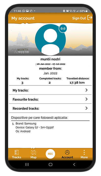
- Trail statistics - first after Muntii Nostri account details:

My trails: number of trails created on the website + recorded trails;
Completed trails: number of trails marked as completed in the application;
Distance traveled: distance achieved by marking trails as completed + recorded trails
- This type of account shows ads
- In order to benefit from offline maps and other functions, you must have one of the 3 types of subscriptions (for 3 months, 6 months)
To do this, access the Be an Explorer! button from the application, which will direct you to the website shop section.
3. Explorer account
Obtained by purchasing an Explorer subscription for 3 or 6 months
Benefits:
- Works on 2 phones, so it can be used with a friend or on two phones;

- Works online and offline - to access maps in any area of the country.
- !!!The download is done exclusively online and exclusively with the Explorer subscription
The maps can be downloaded from the mountain group, using the download button at the top right or from the More menu - Downloaded regions. Within the downloaded region you can see the number of trails corresponding to each region.

- The downloaded regions will appear with a check mark in the list of mountain regions

- Maps can be managed from the mountain group by pressing the delete button or from the More menu - Downloaded regions
- The function for recording trails and points of interest
- SIt can be accessed by pressing the REC button and pressing the Play button

- Points of interest can be added with custom title, category, photos and description.

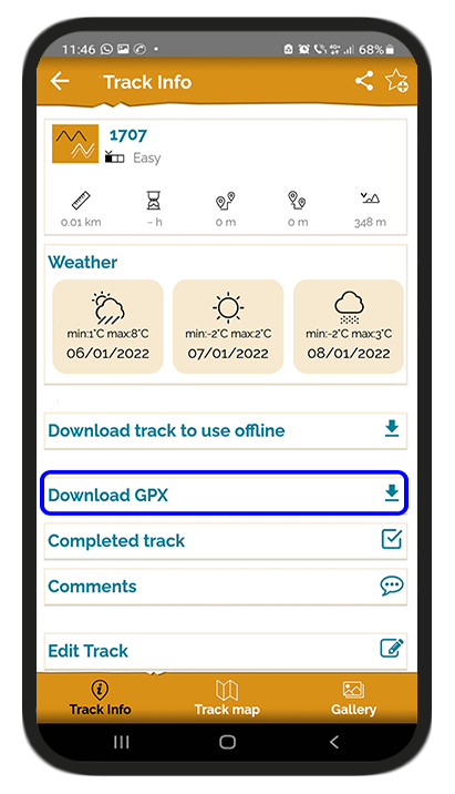
- When saving the trail, title, type of activity, images, and description are added. Recorded trails are saved in My Account, recorded trails section.
- !!! It is recommended to upload it to the server in order to be able to view the elevation profile and to be able to access it in the account. You can share the trail and download the gpx. The gpx is downloaded to the Downloads folder of the phone.
- !!! The trails created on the website must be accessed in My Account and downloaded to the phone in order to be able to access them offline, by clicking on the Download trail button for offline use.
- Once uploaded to your account, the trails will remain private and you will be able to share with other people. A link will open that will send you either to the application, if the other person has it installed or to Muntii Nostri website.
- POI viewing function
- The points of interest associated with Muntii Nostri trails can be viewed with the Explorer subscription.
Sources, huts, shelters, etc., can be viewed along the trail to be followed.
- Search - the search function is performed next to trails and points of interest.
- The search is offline
- Points of interest will be displayed along with the associated trails. For example, if you search for "Urlatoarea", the results will include either POIs with the associated trail or trails that contain Urlatoarea Waterfall in the title or in the stages of the trail. For viewing the associated trails or for visualizing the POIs on the map, tap on the POI and then select a track from the list.

Website
The Premium subscription offers a series of features on the website:
- the ability to import gpx and kml to create trails
- the possibility to see the trail in 3D
- the possibility to see the POIs along the trail